Kuhl Ramblr In The North Cascades

KÜHL, the outdoor apparel company, was nice enough to send me a pair of Ramblr shorts from their new line to try out in the mountains. So, where better to give them a test run than the rugged and beautiful North Cascades.

Just a little background, KÜHL has been my preferred outdoor brand for almost a decade now. I’ve hiked in their pants and shorts extensively and put them through a proper durability gauntlet. I slid down Mt. Doom in New Zealand in KÜHL shorts, ran Hawaii’s Kalalau trail in a pair of Kruxs, hiked through monsoon conditions on the Milford Track in Renegades, and even glissaded down Mt. Rainier in their Radikl shorts.

(Just a few things I’ve previously slid/glissaded/fallen down while wearing KÜHL shorts/pants):

Sliding down Mt. Ngauruhoe aka New Zealand’s stand-in for Mt. Doom

Glissading down Mt. Rainier

Exploring the Blue Ridge mountains in Renegades

Despite all the abuse I’ve put them through, I’ve managed to keep the same few pairs of KÜHL shorts and pants intact and in steady rotation. Which is as good of an endorsement as I can give for a piece of outdoor wear. It almost seems like a detriment to KÜHL’s sales that their shorts and pants are so well made, because I’ve never had to replace them, despite my best efforts to destroy them through chaotic hiking.

But this is about testing out the new Ramblr shorts, so let’s get to that.

KÜHL Ramblr Shorts Review

As outlined on their website, the Ramblr is, “Cut from KÜHL’s exclusive ÜBERKÜHL STRETCH™ fabric…and delivers quick drying and lightweight comfort along with excellent abrasion resistance and sun protection (UPF 50). Our unique dying process delivers a classic look and eight convenient pockets make this short versatile enough for almost any warm weather activity.”

Initially, when throwing them on, the material feels a little heavier than previous KÜHL wear I’ve owned, but I don’t mind that extra bit of sun protection and resistance. I’m always finding new and creative ways to beat myself up on the trails and the added sturdiness is a boon.

What I love

The Fit

Fit always comes first for me. I could have a pair of shorts that are everything-proof, but if they don’t fit well, I’ll immediately swap them out for something more comfortable. I’m the type of person who will pay good money for outdoor apparel and then hike in basketball shorts and a threadbare t-shirt for no logical reason. The Ramblr style is a little longer and narrower than shorts I’ve worn in the past, but this is nice considering that I’m on the taller side and nearly all legs. The tradeoff with the extended inseam can be a lot of uncomfortable shifting, bunching and constriction, but I’m happy to report that the Ramblr feels just as good in motion as it does while at rest. Which brings me to the next aspect I really like.

Versatility

I’m particularly stubborn when it comes to changing out gear while on the move, so I’m always searching for apparel that handles itself well in a range of motions, conditions, and activities. I want a pair of shorts I can hike, bike, and lounge in, which, yes, is an unreasonable checklist, but one that the Ramblr still manages to fulfill. It’s night and day compared to when I first moved to the Pacific Northwest and foolishly tried to hike everything in jeans and a JanSport. I’m glad those days are behind me.

Ramblrs double nicely as a versatile bike short

Pockets

I started doing more wildlife photography during the pandemic, so pockets are a big plus for me. I love being able to quickly shove a pair of binoculars in the side or back pockets. I also have an archaically oversized iPhone 8 that still manages to fit snugly in the side pocket, which seems crazy that this cinderblock of a phone fits in any of these pockets, let alone the secondary ones. Credit to the designers for having great pocket options on a piece of apparel that still manages to gracefully avoid feeling like you are dad-pantsing it around the mountains in cargo shorts.

Pockets for days

Fabric

KÜHL fabric has always mystified me. The Ramblrs, like prior KÜHL apparel I’ve owned, breathe, wick, stretch and remain hard to tear in a way that seems contradictory. That is a dream checklist for outdoor apparel. Especially the quick drying aspect of the fabric, which is amazing for anyone who contends with the unpredictable Pacific Northwest rains. There was also a huge front of wildfire smoke moving through the Cascades while we were camping, so having a lightweight, breathable short style was helpful with the unusually high temperatures. Everything smelled like smoke when we got back, but these shorts are so easy to throw in the wash. Another fringe benefit. Easy to wash outdoor gear. It’s really the little things.

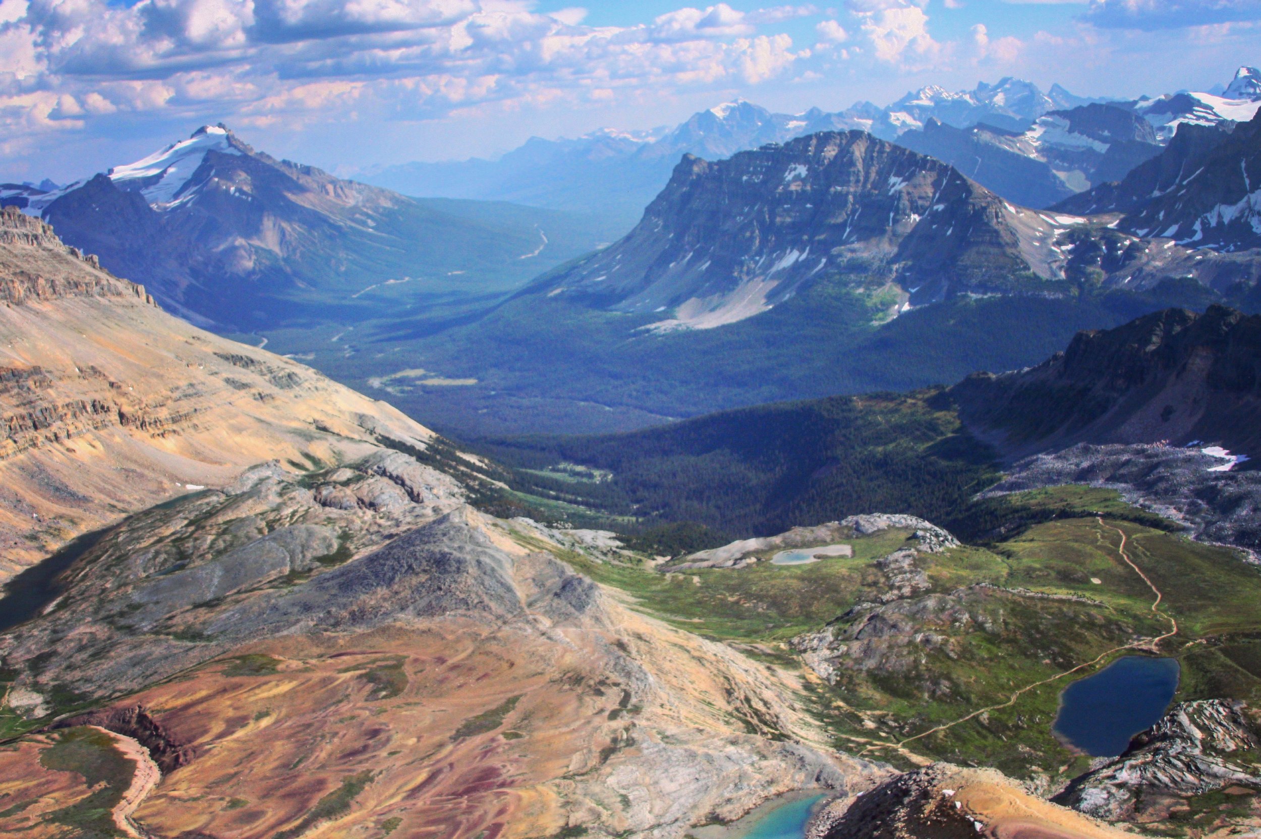
Wildfire smoke moving through the Cascades

Making the Grade

The KÜHL Ramblr is my new favorite piece of activewear. They’re lightweight hiking perfection. A superb blend of rugged leggy freedom and versatile protection. Although I’ve still yet to put them through my standard ‘slide down a volcano’ durability test, I’m sure I’ll be wearing them for years to come.

Helen Lake to Cirque Peak: Banff's Best hike

IMG_0453.JPG

How to Get There: Approximately 40 kms north of Lake Louise on the Icefields Parkway you will find the Helen Lake parking lot. Located just before Bow Lake, opposite the Crowfoot Glacier viewpoint.

Difficulty: The difficulty of this hike depends on where you intend to stop. If Helen Lake is your final destination, then this is a moderately challenging, well labeled tromp through Banff backcountry. Remember your bear spray and hikers of all levels should be able to reach the scenic Helen Lake destination. However, if you intend to summit Cirque peak, this becomes a challenging journey with some scrambling and route finding experience required. 

Distance: Helen Lake: 7.5 miles roundtrip (12km), Helen Lake with Cirque Peak 10.5 miles (17 km) elevation gain: 1,300 feet (400 meters)

Time: 5-7 hours

Helen Lake to Cirque Peak is one of the most popular day hikes on the Icefields Parkway. This well known trail combines all the major elements that draw people to the area: Glaciers, glacial lakes, wildflower flush prairies, panoramic views and a backcountry sense of adventure, all packed into a single intermediate day hike. After slogging through the hordes of tourists that descend upon Lake Louise and Moraine Lake for the summer season, this is the hike that will truly satisfy your adventurous outdoor spirit. 

After departing the trailhead, you will immediately encounter an unforgiving grade as your journey begins, but do not despair, as most of this hike will be a calf-friendly, gradual ascension on a well beaten path. In fact, if you choose to skip the optional leg up to Cirque Peak, this prologue will be the steepest section you will encounter. Trek through two miles of heavily forested trail and the tree line will eventually break, revealing obstructed peeks at the nearby Crowfoot Glacier.  

IMG_0421.JPG

Continue on and the hike will finally open up into expansive valleys flanked by the surrounding Dolomites. Helen Lake awaits you a mile and a half in the distance, topping out at a one way total of 3.7 miles. If you choose to continue on and ascend toward the looming Cirque Peak, you will add a grueling 3 mile up and back leg to your roundtrip journey. Completing this appendage trail however will reward you with some absolutely breathtaking views of Banff National Park. Helen Lake to Cirque Peak stands as my favorite hike in Icefields Parkway because of the summit panorama, especially in August when the wildflowers are in full bloom. 

Helen Lake with the summit of Cirque Peak in the distance. 

Helen Lake with the summit of Cirque Peak in the distance. 

Once you reach Helen Lake, this is a great spot to grab lunch and refuel. Hikers may have to contend with swarms of biting flies that patrol the area, a phenomenon that often flushes hikers upward toward the imposing task of summiting Cirque Peak, or retreating back down toward the relative safety of the river. For those travelers choosing not to make the pilgrimage up the unforgiving Cirque route, I would still encourage a climb above the Helen Lake headwall for an elevated recap of their journey.

The view from above the headwall. 

The view from above the headwall. 

Those attempting to complete the Cirque peak challenge, a steep scree filled giant awaits you. Depart from Helen Lake and take the path around the right side of the water to trek above the headwall. Once you reach the top of the headwall, follow the path onward toward Cirque. One cairn laden path drifts off to the left taking hikers through a precarious section of scrambling along the ledge of the headwall. Navigate your way and rejoin the main path at the base of the Cirque trail. 

The cairn/ledge route. 

The cairn/ledge route. 

From the base of the path, you will now have 1500 feet of elevation gain to conquer over the next mile. In addition to those stifling parameters, most of the trail is loose scree, which makes it an even more strenuous plod upward.      

Getting there. 

Getting there. 

Once you complete the final push and approach the summit, mind your surrounding as you will be boxed in by sheer drop offs on both sides. Locate your footing and stand atop Cirque Peak. Enjoy the benefits of your hard work as you gaze out at one of the best views Banff National Parks has to offer with Peyto Lake, Dolomite Pass, Bow Glacier and the Wapta Icefields in sight.  

The view from the summit is amazing. It is the opening shot of my Centriphone Canada video below.

Trip Report: 7 hours 

Departed Trailhead: 1:30pm

Reached Helen Lake: 3:20pm

Cirque Peak Summit: 5:10pm

Trailhead return: 8:25pm


Summer

Summer was quite busy this year with trips to Hawaii, Canada, San Fran and Oregon to go along with our usual wanderings in Washington. It was really nice to catch up with old friends, explore some new places and swim in the sea. Hope everyone found some peace amongst the chaos this year. 

Canada Tour

This is the video from our recent Canada tour. The B.C. wildfires cancelled our original backpacking route through Mt. Assiniboine and pushed us north toward Jasper, but we still had a great time. A lot of smoke, haze and poutine, but no grizzly run-ins, which I'm always thankful for. This was mostly shot in Banff, Jasper, Canmore and the Icefields Parkway on a GoPro Hero 4 using the Centriphone rig.

I'm going to try to have some write-ups for a few of the hikes we did, especially the longer trails like Helen Lake to Cirque Peak, Plain of the Six Glaciers, Sulphur Skyline and the East End of Rundle. So, be on the lookout for that in the next week or so.

And if you're out hiking, camping or backpacking in anticipation for the eclipse on Monday, I hope you get some great views!

Cape Flattery

Cape Flattery is a great way to experience the coast if you’re looking for a leisurely hike that showcases Washington’s spectacular sea stacks and coastal wildlife. Clocking in at less than two miles and boasting an enticing two hundred feet of elevation gain, it’s an inviting trail for hikers of all experience levels. Outside of the relatively long commute to reach the trailhead, it’s a landmark I would encourage any Olympic National Park visitors to seek out.

Although we drove for almost an hour in white out fog to reach the trailhead and hiked through some residual gloom on the trail, we lucked out with visibility once we reached Cape Flattery's first viewpoint. Still sporting a thick veil of mist, the weather broke just enough that not only were we treated to great views of the surrounding sea stacks, but we also discovered that the cove was full of sea otters, which is secretly how I hope every hike, even those lacking bodies of water or rational places for otters to appear, will end.  

Any muddy stretches on the path gifted by the recent rains were offset by the well-maintained trail, which has planks and boardwalks for visitors to utilize. As the trail guide mentions, the elevation gain over the mile and half round trip is minimal, so day packs and cameras will suffice for gear. But most of all, remember to enjoy the trail. It’s a wonderfully diverse slice of the Olympics that I hope everyone gets a chance to experience.

Upon our return to the car, I also learned that along with being the most northwest point in the contiguous states, Cape Flattery is a popular place to start cross-country bike rides. We encountered a group of bikers beginning their journey at Cape Flattery, destined for the West Quoddy Head Lighthouse in Maine, which is the most northeast tip of the states. An ambitious route of about three months or so I’m told.

And lastly, don’t forget to grab your recreation pass for the hike at the Makah Museum in Neah Bay, which you will encounter about eight miles before the trailhead as you drive west on 112. The pass is good until the end of the calendar year and can also be used at Shi Shi.

Mount Storm King

Mount Storm King is easily one of the best names in the Olympics, named for a Klallum tribe legend, but similarly conjuring up imagery of moody Norse-Gael coastal peaks. While the trail may lack anything quite as aggressive as its title suggests, it does offer wonderful elevated views of Lake Crescent.

After a quick jaunt out to Cape Flattery, we decided to add Mount Storm King on the return trip home as we needed to get some conditioning in for backpacking season. The trail is quite popular in the Lake Crescent area with the nearby Spruce Railroad Trail closed until July, and Storm King sharing a trailhead with the also well attended Marymere Falls. Trails like Storm King and Hurricane Ridge compete for the attention of elevation starved beach campers returning to the city via 101, so expect a gentle stream of foot traffic on your visit.

Storm King is a steep, moderately challenging hike that begins with a leisurely stroll along Barnes Creek before splitting at the half-mile marker. The marker sits at the base of a giant boulder, which serves as an appropriate post for the detour since the Klallum legend tells of Mount King hurling a giant boulder from the peak to create Lake Crescent and Lake Sutherland.

Steep switchbacks punctuate the trail after the split, but it never approaches the completely dishearten grade of something like Old Mailbox trail or the depraved urban training ground of Capitol Hill’s Howe Street stairs. We overloaded our packs for conditioning purposes, but otherwise hiking poles and large water bottles would have sufficed for gear. The trail is dry and well maintained, but the last section of Storm King has some exposed scrambling with ropes installed to aid climbers. However, most will be content to stop at the viewpoint just short of the true summit where you receive your best views of Lake Crescent without the risk of exposure.

We ate lunch at the viewpoint, enjoyed the view and soaked in the day’s pristine weather. It was wonderful. After a nice break, we headed back down and upon returning to the car, our 4.4 mile roundtrip clocked in around 2 hours and 30 minutes. We were taking our time though, so regard this as a trail time on the slower side of things.

Trip Tracker:

Departed trailhead: 1:45 pm

Arrived at the trail split: 2:00 pm

Reached the summit: 3:15 pm

Returned to the trailhead: 4:15 pm

Lake 22 - Into the Woods

IMG_9059.JPG

Lake 22 is an easily accessible, moderately challenging North Cascades tromp that quickly justifies any Gore-Tex purchases you made for this year’s extended rainy season. Despite its bafflingly sterile name, this is a hike I would recommend to anyone looking for a great trail in relatively close proximity to the city. Armed with a battery of peripheral waterfalls, old growth forests, gentle creek crossings and steady foot traffic, Lake 22 is that spring gem you've been looking for.

We hit the trailhead just after 2:00 pm, hoping that the day’s overcast weather would burn off by the late afternoon. It unfortunately did not, but the silver lining was that it did create some fantastic mood lighting for the debris-riddled talus slopes at the heart of the hike. And if you’re a more pragmatic soul that’s not into mood lighting or hiking through forests that look haunted, I guess you could say the fog and drizzle also kept temperatures comfortably cool, which is my preferred hiking conditions.

This forest is totally not haunted. Promise. 

This forest is totally not haunted. Promise. 

Most of the trail has thawed out, leaving the first two miles wet, but relatively snow free. The last mile still has deep pockets of snow and some troublingly deep posthole opportunities. We saw plenty of people completing the hike in flats and sweatpants, and while I will always defend the right for people to hike in casual attire, I would recommend traction devices and hiking poles if you have them, especially for your descent down the mountain. It will cut down on unintentional glissading and startled yelling, which seemed to be the theme of the day.

We reached the lake around 4:00 pm just as the clouds started to break and suggest the existence of the sun. Lake 22 is stunning regardless of the weather, but it was nice to see some blue in the sky, if only for a moment. We grabbed a bite to eat and watched several avalanches crack and sever off the backside of the peak, making for a truly surreal sight. Definitely one of my favorite lunch spots of 2017.


The weather improved on the descent and we were back in the parking lot by 6:00 pm, clocking in around four hours for the hike. We were taking our time and just kicking off spring training for a busy summer hiking season, so our times are a little on the slower side if you’re looking for median estimates for the trail. We are meanderers, not hustlers.

Either way, Lake 22 is a great spring hike if you’re looking for an alternative to the North Bend staples. It may be just as busy as some of the I-90 classics, but it’s a welcome change of scenery.

Trip Log:
Starting the trail: 2:11 pm

Arrive at Lake 22: 4:15 pm

Returned to the car: 6:01 pm