
Mt. Doom (more commonly known as Mt. Ngauruhoe) is a steep, slushy, scree-riddled volcano located along the Tongariro Alpine Crossing on New Zealand’s north island. A peak where two steps forward feels like two steps backward on your slog to the interminable summit. Nonetheless, it's a hardship that seems appropriate for the task of climbing Mt. Doom. If there were gondolas up to Mt. Doom or I hiked Mt. Doom and it made me feel good about myself, it wouldn’t quite sit right with me. Mt. Doom really needs to make you hate yourself a little bit and to its credit, it did.

19.4 KM = 12ish miles, but you don't need to do all 12 miles to complete the Mt. Doom experience. You are looking at a 6-7 hour hike though.
To begin your journey up Mt. Doom you have to head to Tongariro National Park and seek out the Mangatepopo Car Park at the end of Mangatepopo Road. Climbing the peak is a detour on one of New Zealand’s most popular day hikes, the Tongariro Crossing, where trampers traverse a patch of Mordor like terrain, winding past volcanic pools, geothermic vents and lava flows in New Zealand's oldest national park. You will follow the Tongariro Crossing trail for about two hours, after which you will be given the opportunity to split from the crossing to begin the formidable chore of climbing to the top of the infamous Mt. Doom (Mt. Ngauruhoe) summit.

At the turnoff for Ngauruhoe, you're looking at about a three hour roundtrip from sign to summit back to sign.
Let’s just get this out of the way. This hike sucks at times. The déjà vu of hiking Mount St. Helens was not lost on me while I was doing this trail. And the day I attempted Mt. Doom, it was hot. Probably in the high 80s. The breeze that arrived with the elevation gain was welcome at first, but eventually just became another force of nature battering you back down the mountain as you crawled your way up its quicksand-like exterior.
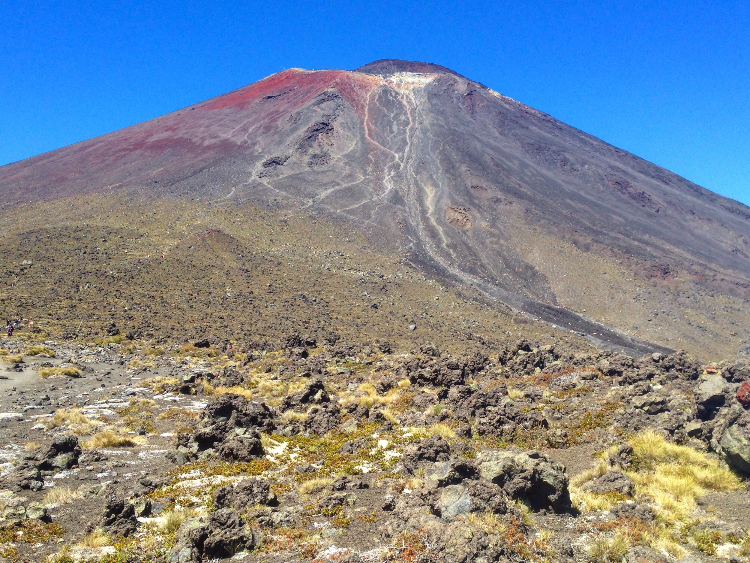
Mordor-lite landscapes as far as the eye can see.
It wasn’t the museum of false summits and broken dreams that Mount St. Helens was, but as I mentioned, it’s in the same ballpark. Ngauruhoe is more akin to a compact version of Helens. You can clearly see your endpoint, even if it seems impossible to reach once you start sloshing your boots into the Mars red scree fields.

Blood red scree fields as far as the eye can see.
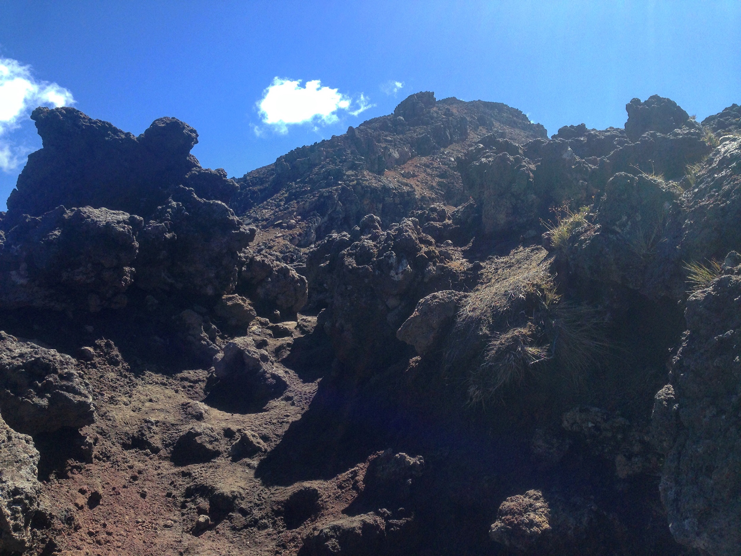
At some point on your climb up Mt. Ngauruhoe, it becomes apparent that the best ascent route is to abandon any sense of a path and gravitate toward the sharp volcanic rock clusters that you were previously avoiding. These razor sharp outcroppings provide something solid to pull/crawl yourself up the mountain with, even if it’s like grabbing a hand railing made of broken glass. This is the portion of the hike where gardening gloves become invaluable. Because I am an excellent planner, my gardening gloves were still in an amazon delivery box back in Seattle when I set out for Mt. Doom, having arrived the day after I left for New Zealand. Still, having climbed Mount St. Helens and seeing the aftermath it had on gloveless hands, I had a backup pair of regular gloves on hand for this climb.

No, Amazon Prime didn't let me down. I let myself down.
As I inched my way up this big dumb volcano, I saw plenty of people lose faith and give up on the quest like a bunch of Boromirs. And I don't blame them. This climb was taxing. And while I certainly wouldn't classify it as a dangerous hike, it's somewhere in the range of difficult to sketchy. Either way, the novelty of saying I climbed Mt. Doom was too powerful to really give any thought to turning around before I reached the summit. I wasn’t going to fly to New Zealand to hike some of Mt. Doom. No one would have cared if Frodo did 2/3 of Mt. Doom, buried the ring under a rock and then called for his eagle uber. So, I pushed on with my blister riddled feet, passing into the muttering stage of the hike. The muttering quickly disappeared when I finally, after a metric forever, reached the summit and turned around for one of those “oh, right,” views, where you immediately understand why people climb this mountain outside of the perceived novelty value of reaching the top of Mt. Doom. It's gorgeous.

Okay, fine. I get it. The view is awesome. This doesn't mean we're friends though, Mt. Doom.
The summit of Mt. Ngauruhoe provides a stunning panorama of the crossing, its volcanic pools dotting the landscape like translucent puddles, the clouds gliding over the plains like wistful guardians, the Neapolitan strips of farmland leaning endlessly into the horizon. It's breathtaking. Turn and peer into the massive cranial summit crater, which looks as vast and unforgiving as you’d expect from the top of Mt. Doom.
The vine equivalent of climbing Mt. Doom in a minute.
After I ate some lunch and tossed my metaphorical ring into the crater, I took a few pictures to prove I was foolish enough to climb this mountain and started back down, exhausted, but happy to have completed the task at hand. Somehow, I had managed to condense the entire plot of Lord of the Rings into a single day. I left the Shire the day before at 4pm and made the summit of mountain by 2:00 pm the next day. Eat your heart out, Frodo.
But the fun was not over yet. The mountain is so steep that the endorsed method of descending is to literally plant your feet and slide down these lightly channeled paths of rock and scree. Most of the time when you see someone unstably boot skiing down a mountain, you remind yourself to not follow any part of that soon to be seriously injured climber’s route. But in this case, it is the way to go. There are no easy outs on Mt. Doom. Much in the same way that there are no pleasant means to make your way up this mountain, there are no pleasant means of descending either. Everything must be terrible. By the time you hit level ground again, your boots with be so filled with rocks, they cease cutting into your ankles and congeal into a solid mass rock liner, becoming more of a quiet discomfort than any sharp jarring pain.

Rocks in the socks.
After you have completed your descent, make your way back to the trail split and pay close attention to retrace your path back toward the Mangatepopo Car Park. Do not proceed to the right and continue on the Alpine Crossing trail. It does not loop around to the Mangatepopo Car Park and you will find yourself stranded in another carpark, at the mercy of tour bus operators who may take pity on you and shuttle you back to your car back at Mangatepopo. I managed to finally hobble back to my beater rental in just under six hours total for the trip. All and all, it was a difficult but rewarding hike. Definitely one for the books.
Next. A quick stop in Waitomo to see the glow worm caves and then onto the south island where Christchurch and Mt. Cook await.
Mt. Doom Trip schedule:
Left car: 10:15 am
Reached turnoff for Mt. Ngauruhoe summit: 11:50 am
Summited Mt. Ngauruhoe: 1:50pm
Summit turnaround: 2:00 pm
Boot skied back to trail turnoff: 2:50 pm
Back at car: 4:00 pm
Getting there: Mangatepopo Car Park. The car park is often filled with hikers attempting the crossing, so you may have to improvise parking on the gravel road leading up to the carpark by using one of the cone designated makeshift shoulders. Prepare yourself for the possibility of adding anywhere from a quarter mile to a half mile walk to your trekking plans. After locating parking, you will follow the Tongariro Crossing for about two hours, after which you are given the opportunity to split from the crossing to take on Mt. Ngauruhoe. The signage for this trail is very thorough, so as long as you pay close attention, it should be a relatively intuitive route.
Stray Observations:
- Listening to the LOTR soundtrack while climbing Mt. Doom is the way to go. Howard Shore put on a masterclass with that soundtrack.
- Staying at the Plateau Lodge National Park Village before my Mt. Doom run was one of my favorite accommodations on the trip. It's nothing extravagant, just a small family run lodge with paper thin walls, the best Kiwi accents around and a great community kitchen, but I got to hop in a hot tub and soak my butchered feet when i got there, so it gets a glowing recommendation from me.
- One does not simply walk into Mordor. They drive two to three hours from Hobbiton to get there. Just in case you were wondering.
